 sales@uslandgrid.com
 Phone : 877-870-8872



Most Parcel Datasets Look Similar on the Surface
Across the U.S., parcel data is sourced from thousands of local jurisdictions - each with different formats, attributes, update cycles, and levels of completeness. That fragmentation creates real problems for teams working across counties, states, and regions.
Where Parcel Data Breaks Down
✓ Inconsistent schemas across counties
✓ Missing or mismatched ownership fields
✓ Unreliable acreage and valuation data
✓ Time lost stitching datasets together
USLandGrid Parcels Are Engineered for Consistency
We’ve built our nationwide parcel dataset around the challenges that slow teams down: fragmented sources, inconsistent fields, outdated records, and delivery formats that don’t work well in production.
160+ Million Parcel Boundaries
What Makes Us Different
Standardized Nationwide Schema
No county-by-county stitching or field translation required.
Frequent, Predictable Updates
Designed for teams that need current parcel intelligence, not stale snapshots.
Analysis-Ready Geometry
Clean parcel boundaries built for GIS, analytics, planning, and operational use.
Production-Ready Delivery
Available in FGDB, Shapefile, GeoPackage, CSV, KML, and Feature Services.
3,200+ U.S. Counties
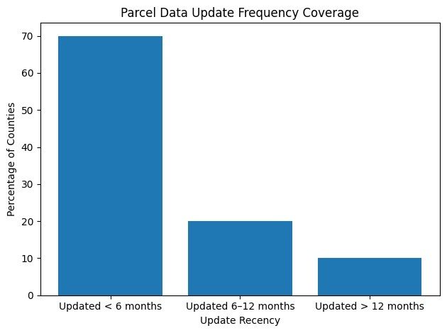
Update Frequency Matters
This is where many parcel datasets fall apart. USLandGrid is built around frequent, transparent refresh cycles.
70%
of counties updated within 6 months
90%
of counties updated within 12 months
Full Schema Transparency
We make the full data schema available upfront so your team can evaluate exactly what you’re getting before committing.
Built for Teams That Depend on Parcel Data
For teams working in energy, infrastructure, utilities, land development, government, and planning, parcel data is not just another layer.
It is a foundation layer for decision-making.